Traffic Calming
Vision Zero is the City of Somerville's strategy to eliminate traffic fatalities and severe injuries. Designing our streets for safety is critical to eliminate traffic violence. One of the ways we can do that by installing traffic calming features that slow speeds. Learn more about how we can reduce speeds and increase safety below.
To see all implemented and currently planned traffic calming installations, check out this citywide map.
Traffic Calming is a way to reduce motor vehicle speeds and improve the safety and livability of our streets. Traffic calming can be achieved in a variety of ways but is usually done by making physical changes to the streetscape.
Below are a number of traffic calming features the City uses to reduce vehicle speed and increase safety for all people on our streets.
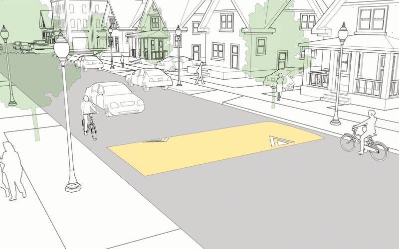
Speed Humps
Raised asphalt features that reduce vehicle speed.
What are speed humps?
Speed humps are asphalt traffic-calming devices intended to reduce vehicle speeds to 10 to 15 mph. These asphalt structures are 3-4 inches high, 12-14 feet wide, and 3-6 feet long. We paint them with white triangles and yellow stripes and place signage nearby to ensure they are visible to approaching vehicles. Speed humps are typically placed 200 feet apart to prevent people from speeding in between them.
Speed humps maintain access for residents, first responders, and services such as street sweeping and snow removal, and deliveries. Speed humps do not impact parking or drainage.
How are streets selected?
We look at a range of factors such as the volume of vehicles on a street, speeding behavior, and proximity to schools, parks and Community Path crossings to identify where speed humps are needed. Speed humps are primarily used on relatively flat and straight residential streets. They are generally not appropriate for wider, busier streets.
Speed Humps in Our City
Speed humps were installed along Sycamore Street, including at the intersection of Jerome Court during the summer of 2022. Vehicles speeds were recorded before and after speed hump installation. The results show a substantial decrease in the proportion of vehicles speeding at this location.

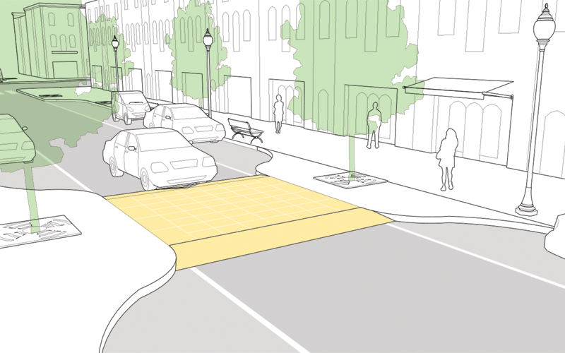
Raised Crosswalks
Make crossing the street safer and more comfortable.
What are raised crosswalks?
Raised crosswalks make crossing the street safer and more comfortable for everyone. Since they are elevated (roughly to sidewalk height), people driving must slow down as they approach the crossing.
Because they are sidewalk height, they enable people using wheelchairs and other mobility devices to cross more easily.
How are streets selected?
Raised crosswalks are appropriate for streets where there is high volume of people walking and crossing the street. They must also be designed so that they do not interfere with drainage or utilities. Because of this added complexity, raised crosswalks are often installed as part of more comprehensive street reconstruction projects.
Raised Crossing in Our City
Raised crossings were installed along Holland St. during the summer of 2022 as part of comprehensive safety improvements along the street. These crossing provide a safer experience for the high volume of pedestrians that travel along Holland St. and to Hodkins-Curtis Park.

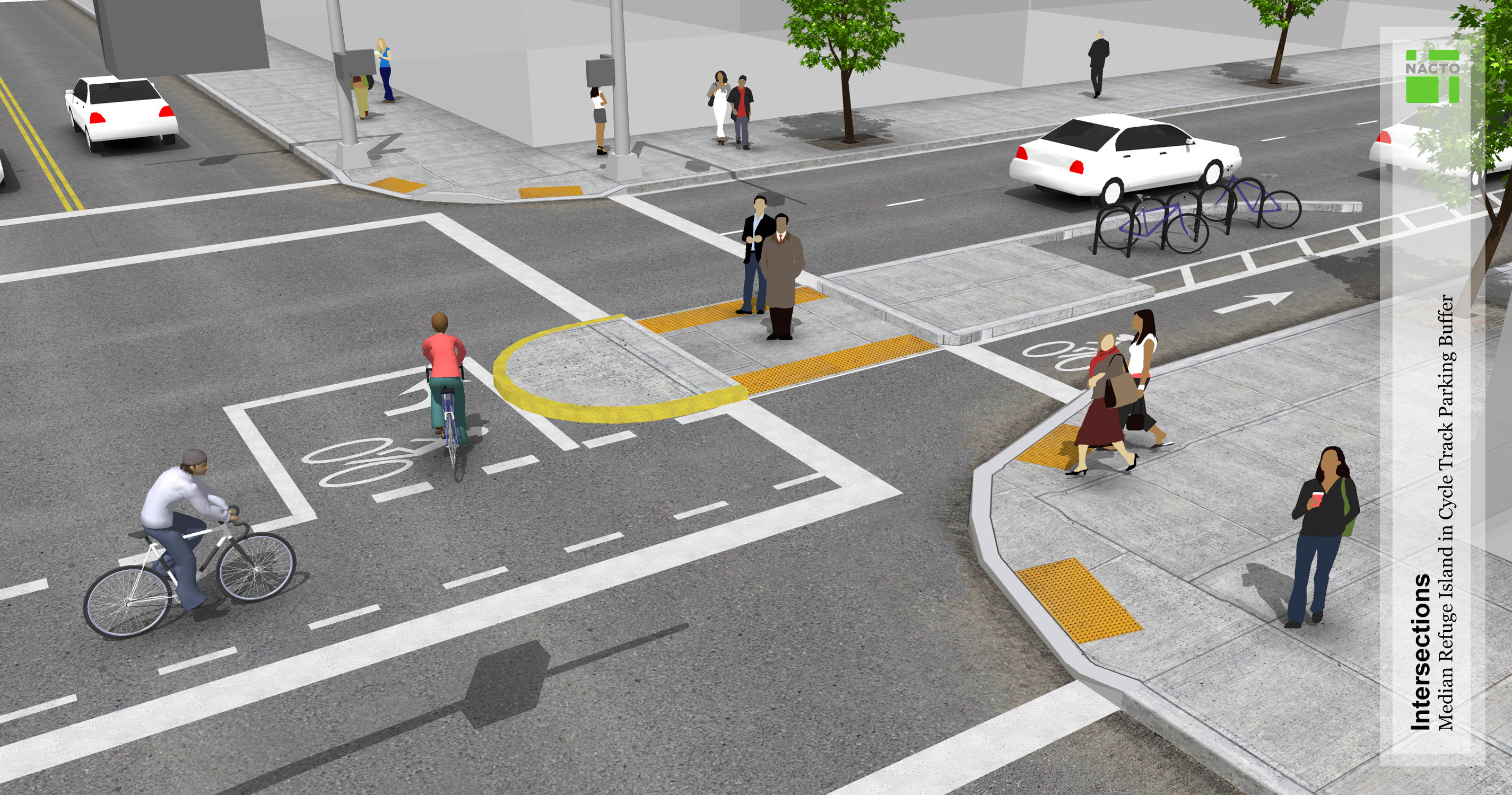
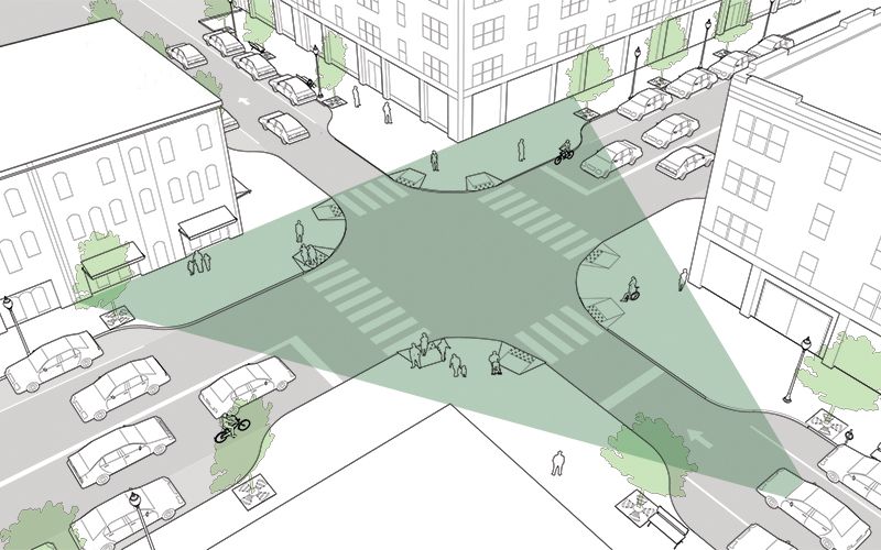
Crossing Islands
Provide a safe place to pause while crossing multiple lanes.
What are crossing islands?
Crossing islands are traffic-calming devices that provide people with a safe place to pause while crossing multiple traffic lanes. Crossing islands also reduce vehicle turning speeds by preventing people driving from taking fast, shallow turns.
Crossing islands can be built with raised concrete and granite or with paint markings and vertical flexible plastic posts. After construction, we paint yellow long lines around the new structure on the street asphalt and install white median signs to ensure they are visible to approaching vehicles. Travel lanes may be shifted to fit around any new concrete structures. Crossing islands do not impact drainage, street sweeping, emergency services, or snow removal.
How are crossing island's locations selected?
We look at data such as high crash rates, and pedestrian traffic. Crossing islands are more likely to be found on wider streets that have a higher volume of vehicles. They are not appropriate for more narrow residential streets.
Crossing islands in Our City
A crossing island was installed at Broadway and Winchester Street in early 2022. Vehicles speeds were recorded before and after speed hump installation. The results show a substantial decrease in the proportion of vehicles speeding at this location.

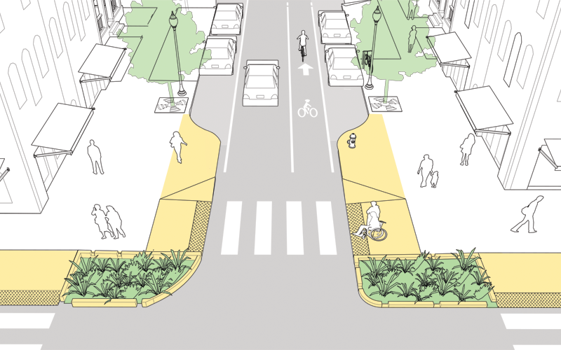
Curb Extensions
Shorten the distance from one side of the street to the other.
What are curb extensions?
Curb extensions, also known as bump outs, extend the sidewalk into the parking lane to shorten the distance from one side of the street to the other, making it safer and easier to cross for everyone.
Curb extensions also make it easier to see people crossing by preventing vehicles from parking too close to the crossing.
How are streets selected?
Curb extensions can be installed on a range of street types where there is on-street parking. They can be used mid-block on higher volume streets to slow traffic and make crossing easier. They can also be used to create a gateway to smaller, more residential streets—signaling to people driving that they are transitioning to a slower speed street and tightening the turning radius to reduce speed.
Curb extensions can also be used as bus stops (also known as bus bulbs). By aligning the bus stop with the parking lane, curb extensions enable easier, safer, and more efficient boarding.
Curb Extensions in Our City

Clear Corners/Daylighting
Increase safety by restricting parking near crossings.
What are clear corners?
Parked vehicles near crosswalks can blocks views of people crossing the street. By restricting parking ahead of crosswalks, we’re able to increase visibility for people driving and reduce the likelihood of crashes. This restriction of parking is part of the City’s Vision Zero plan to eliminate traffic fatalities and severe injuries from Somerville’s streets. Clear corners also make it easier for first responders, delivery truck, and other large vehicles to turn more easily and safely.
We paint a box with diagonal lines to mark the area where parking is prohibited. We install "No Parking" signs alongside pavement markings in commercial districts. In especially high traffic locations, we also add plastic posts in the space as a reminder. In construction projects, we can build curb extensions using granite and concrete to prevent people from parking too close.
How are clear corner locations selected?
Local, state, and federal laws prohibit parking between 20 and 30 feet ahead of a crosswalk or intersection. To bring the City of Somerville into compliance and to focus on key intersections of concern, the City is prioritizing streets with higher intersection crash rates.
Clear Corners in Our City

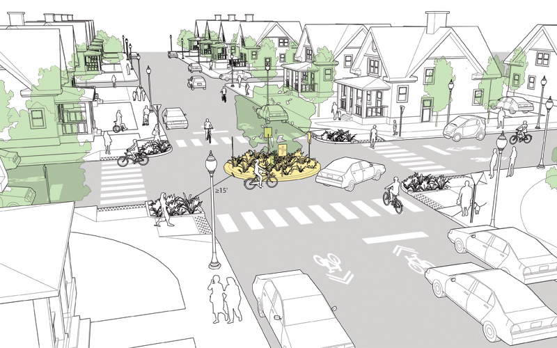
Neighborhood Traffic Circles
Improve safety and slow traffic at otherwise uncontrolled intersections.
What are neighborhood traffic circles?
Neighborhood traffic circles reduce vehicle speeds at intersections. They encourage people driving to slow down at key crossing locations while also providing a space to plant trees or other plants.
Neighborhood traffic circles often feature a center island and sometimes curb extensions to create one lane around the circle. They can also include plants, trees or greenery in the center of the island. Neighborhood traffic circles are ideal for intersections that don’t have stop signs but can still be used at stop-controlled intersections. People driving must stop and watch for people crossing in the crosswalk or oncoming vehicles first before entering the circle.
How do you travel through a neighborhood traffic circle?
Since these are stop-controlled intersections, only one person driving or biking is allowed to pass at a time. Left turns can be taken in front of the circle. You are not required to go right and all the way around like a rotary.
Neighborhood traffic circles are designed to maintain access for emergency responders and sanitation trucks, and allow for stormwater drainage, street sweeping, and snow removal operations.
How are intersections selected?
We look at intersections on streets that serve as large connectors. We incorporate any available speeding data collected on the street. We look at a street’s design and if it has large distances where it is very straight and there are few locations where a vehicle needs to stop at a traffic light. We then prioritize intersections that are next to schools and parks. Neighborhood traffic circles are more likely to be installed on residential streets. They are not appropriate for multi-lane streets, busier streets, or streets with MBTA bus routes.
Neighborhood Traffic Circles in Our City

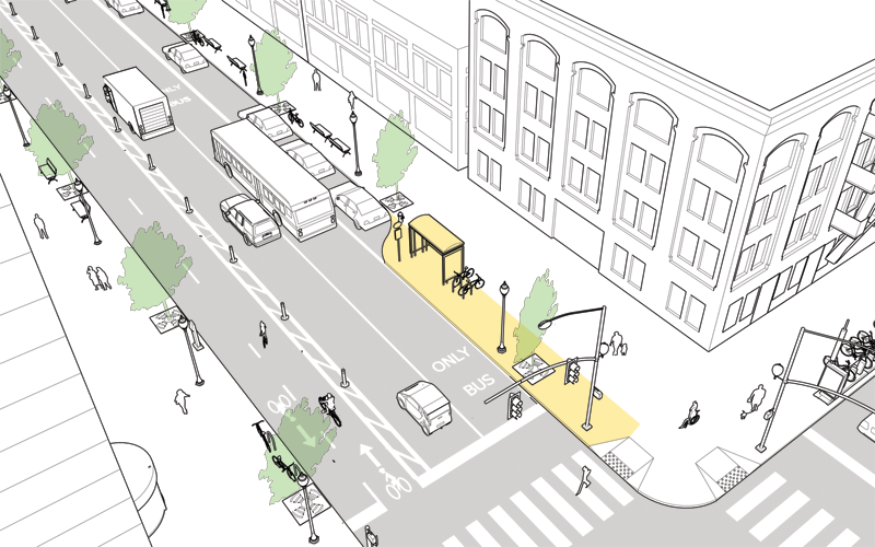
Floating Bus Stops
Provide safe, dedicated waiting and boarding areas for bus riders.
What are floating bus stops?
Floating bus stops are sidewalk bump outs that provide dedicated waiting and boarding areas for bus riders, while streamlining bus service and improving accessibility by enabling the bus to stop in the travel lane rather than having to pull over to the curb. Floating bus stops are separated from the sidewalk by a bike lane, eliminating conflicts between buses and bikes at stops and improving safety for people biking.
Floating bus stops are constructed like sidewalks with raised concrete areas and granite curb. Yellow paint markings are often painted around the new structure on the street asphalt, and fluorescent signs, or concrete bollards might be placed on top to ensure they are visible to approaching vehicles. Some floating stops have greenery incorporated at the front and back of the stops supporting stormwater drainage. They do not impact street sweeping or snow removal.
How are floating bus stop locations selected?
New floating bus stop locations are often identified on street segments undergoing reconstruction. Eligible locations must have a MBTA bus route and are designated for protected bike lanes in the Somerville Bicycle Network Plan. We look at the width of the street and evaluate the curves of the travel lanes to determine if a location is ideal for a floating bus stop. Floating bus stops are more likely to be found on wider streets. They are not appropriate for smaller residential streets that do not have enough width.
Floating Bus Stops in Our City
Floating bus stops were constructed on Somerville Avenue providing dedicated space to wait for the Route 87 bus as part of the Somerville Ave. Utility and Streetscapes Improvements project.

The City continuously gathers feedback from residents about speeding and street safety concerns. There are multiple ways to share your feedback with City staff.
- Contact the City’s 311 Services via phone call, text, email, or using the app.
- Email your feedback to the Mobility Division at transportation@somervillema.gov.
- Submit a traffic calming petition.
The City uses data that looks at speeding, vehicle volumes, and crash rates to identify locations for traffic calming installations. Currently, the City prioritizes locations near schools, parks, community path crossings, and larger affordable housing developments, or those with high crash rates. Traffic calming is also often implemented in pavement and sidewalk reconstruction projects through the City’s Pavement Resurfacing Program.
More on submitting a traffic calming petition
The City conducts an annual analysis of traffic calming needs based on data collection, constituent requests, and staff recommendations. Beyond these mechanisms, you can work with your neighbors to fill out a petition to have your street evaluated for traffic calming. Complete the petition form and submit it to the Traffic Commission Administrator at trafficcommission@somervillema.gov or at the Parking Department, 133 Holland Street, Somerville, MA 02144. Upon submission, the petition will be verified with City records to validate the residency status of the petitioners. The petition must be signed by the inhabitants of households who legally reside on the street. Only one handwritten signature per household will be considered.
Upon verification, the City will begin to work on a traffic calming assessment. This includes collecting speed and volume data, and evaluating the street based on priority considerations like nearby land use. Data collection generally occurs in the spring or fall. The City will then determine if your street meets current traffic calming installation priorities. The petition does not guarantee that your street will receive traffic calming changes. Streets that meet the current eligibility criteria will be put on the prioritization list. Please note that this is not the only way to have a street evaluated.
Previously submitted traffic petition assessments since 2020:
- Victoria Street (2023)
- Elston Street (2023)
- Glen Street (2023)
- Laurel Street (2024)
- Lexington Avenue (2024)
- Ivaloo Street/Harrison Street (2024)
- Trull Street (2024)
- Irving Street (2025)
- Farragut Avenue (2025)
- Norfolk Street (2026)
Each year the City works to identify locations where speeds hump could effectively reduce vehicle speeds and increase safety. The City then uses a data-driven process to prioritize these locations and ensure traffic calming interventions are equitably distributed.
Annual Speed Hump Prioritization
Feedback
Please submit website feedback using this form. Be sure to include:
Thank you for your feedback!